The OpenCycleMap global cycling map is based on data from the OpenStreetMap project. At low zoom levels it is intended for overviews of national cycling networks; at higher zoom levels it should help with planning which streets to cycle on, where you can park your bike and so on.
The map is updated every few days with the latest data from OpenStreetMap. News about OpenCycleMap can be found in the OpenStreetMap archives on my blog.
Key
 |
 |
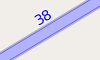
National Cycle Route |
 |
 |
Regional Cycle Route |
 |
 |
Local Cycle Route |
 |
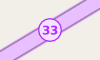
National Node Network | |
 |
Regional Node Network | |
 |
Local Node Network | |
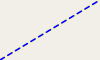 |
Cyclepath | |
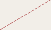 |
Footpath (no cycling) | |
 |
Large Bicycle Parking, with capacity >= 20 | |
 |
Small Bicycle Parking | |
 |
Bicycle shop | |
 |
Bicycle Rental station | |
 |
Toilets | |
 |
Cafe | |
 |
Drinking Water | |
 |
Pub | |
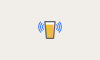 |
Pub with free wifi | |
 |
Shelter | |
 |
Hospital | |
 |
Post Office | |
 |
Postbox |
Credits
- Height Data is from ASTER and is available in the public domain.
- All other map data, including all cycling-related data, is from OpenStreetMap.org contributors and is licensed under the Open Data Commons Open Database License (ODbL).
- The map tiles are available for re-use under the Creative Commons Attribution Share-Alike 2.0 License. For full details see the full terms and conditions
Donations
If you appreciate the work that’s going on here and would like to contribute to the project, then join OpenStreetMap and help them out. If you can’t, or don’t want to, or want to help even more than you are already, then you can donate using this button - you don’t even need a PayPal account, you can use a credit or debit card by looking for a link on the next page.